Exciting new ‘World War I’ layer launched on Know Your Place
A new resource layer highlighted with eye-catching poppy symbols went live on the Know Your Place website in March (see http://www.kypwest.org.uk).
For the past few months Cheltenham Local History Society volunteers at Gloucestershire Archives have been helping to create this resource from local historian David Drinkwater’s personal World War I project.
Over the years David has amassed well over 7,000 images of servicemen and women published in the wartime issues of the Cheltenham Chronicle and Gloucestershire Graphic, also producing a spreadsheet to index them. When David and I met up during a KYP event at last year’s Gloucester History Festival, we realised that KYP might be a great way of sharing this collection with the wider world.
We decided to test it out with Cheltenham images. Some detective work was needed to be able to pin the images to the exact locations on the KYP map. This is where the local knowledge of our Cheltenham volunteers was invaluable. After an introductory training session and with some additional research material provided by David (copies of directories and electoral rolls, and also James Hodsdon’s invaluable Historical Gazetteer of Cheltenham), the team set to work finding precise addresses for the Cheltenham entries and pinning the images and associated information. All the entries created so far have been uploaded to the new KYP information layer titled ‘World War I’.
The screenshots that follow show you what you can find there.
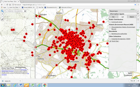
1. I entered ‘Cheltenham’ in the address box (top left of screen) and ticked to select the World War I layer in the right hand menu to limit my view to the new layer. As you can see, Cheltenham is full of poppies! (KYP automatically opens up with the first edition OS map on the left half of the screen and the modern map on the right – you can drag the vertical bar to reveal more or less of each map or select different maps from the Basemaps menu)
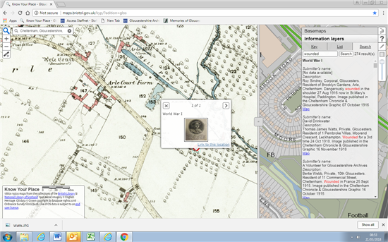
2. You can then either zoom in to browse entries by location on the map, or use the Search tool on the menu to look for a specific name or keyword. I typed in ‘wounded’ and got 274 results. The first 3 are shown on the screenshot (you would just scroll down to see all the results). Each result has a hyperlink which takes you directly to the location on the map. Here I clicked on the first entry, for Roy Sindley, and the thumbnail record popped up:
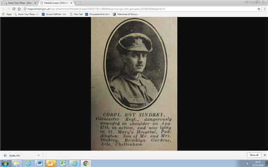
3. The description attached to the KYP entry is a summary of the original newspaper article. Just click on the thumbnail image to see the scanned image of the full article, as in the next screenshot. Roy’s photo and the details of his injury would have been sent into the newspaper by his parents:
At the moment there are 3 information layers for KYP Gloucestershire – a Community layer created by submissions from local heritage organisations and individuals, an Industrial Archaeology layer created as a pilot for KYP by the Gloucestershire Society for Industrial Archaeology and the World War I layer.
The WWI layer will eventually extend well beyond Cheltenham. The Cheltenham Chronicle and Gloucestershire Graphic circulated widely across Gloucestershire including parts of present day South Gloucestershire. We’re looking for additional volunteers to help complete this task – it can be done via internet access at home or at the Archives. Please contact me if you are interested in getting involved.
Julie Courtenay, Collections Leader, Gloucestershire Archives julie.courtenay@gloucestershire.gov.uk